
HG-HyperUAV-MSRS
Integrated UAV Multi-Source Payload Remote Sensing Observation System
400–2500nm Spectral Range · Dual Use for Airborne and Ground Operations
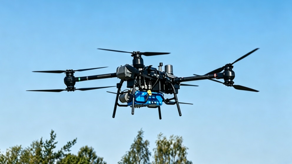
An integrated UAV remote sensing observation system engineered for the simultaneous acquisition of multi-source remote sensing data, enabling synchronous collection of full-band hyperspectral data, infrared thermal imagery, LiDAR point clouds, and orthophotos.
Product Introduction
The HG-HyperUAV-MSRS is an integrated airborne multi-source payload remote sensing observation system developed by Hagorun Technology Limited to meet the demand for multi-source payload remote sensing data measurement. Flying a single flight line allows for the simultaneous acquisition of 400–2500nm full-band hyperspectral data, infrared thermal maps, LiDAR point cloud data, and aerial imagery. This product can be adapted to various aircraft models, including multi-rotor and fixed-wing UAVs, delivering stable data acquisition capabilities and reliable system performance. It is widely used in precision agriculture, mineral exploration, forestry science, and national land resource surveys.
In addition to the hardware, the system is equipped with fully localized multi-source payload control and post-processing software. The control software enables one-key synchronous start/stop of 4 types of payloads, real-time display of payload status and flight attitude, and fault alarms. The post-processing software supports geometric correction, radiometric calibration, point cloud processing, and infrared data analysis of multi-source remote sensing data. Both the software interface and operational workflows are designed around user habits, greatly enhancing the convenience of multi-source remote sensing data collection and analysis.
Technical Features
Multi-Source Fusion
Integrated Hyperspectral + Infrared + LiDAR + Aerial Photography
One-Key Control
Synchronized startup and data collection for multi-payloads
Broad Spectral Range
Covers visible, near-infrared, and short-wave infrared ranges
Modular Design
Supports rapid adaptation across different UAV platforms
Airborne & Ground Integration
Supports dual-mode operations for both airborne and ground use
Strong Platform Adaptability
Compatible with fixed-wing, multi-rotor, and ground vehicles
Application Fields
Precision Agriculture & Smart Farming
Forestry Resource Survey & Monitoring
Urban & Coastal Remote Sensing Monitoring
National Land Resources Monitoring & Assessment
Geological Survey & Mineral Identification
Water Body & Ice/Snow Environmental Research
Technical Specifications
| Item | Specifications |
| Product Model | HG-HyperUAV-MSRS |
| Hyperspectral Imager | |
| Detector | Cooled Si+MCT Detector |
| Spectral Range | 400–2500nm |
| Spatial Pixels | 1240 @ 400–1000nm 620 @ 1000–2500nm |
| Spectral Channels | 400 @ 400–1000nm 300 @ 1000–2500nm |
| Spectral Resolution | ≤3.0nm @ 400–1000nm ≤6.5nm @ 1000–2500nm |
| Digitization | 16-bit |
| Frame Rate | 150Hz |
| Camera Interface | CameraLink / USB |
| Data Storage | 4TB |
| Data Format | BIL / BIP / BSQ |
| Infrared Camera | |
| Detector | 640×512 Uncooled Infrared Focal Plane Array (FPA) |
| Wavelength Range | 7.5–14μm |
| Thermal Sensitivity | ≤35mK |
| Frame Rate | 30Hz |
| Temperature Range | -20°C to +500°C |
| Temperature Accuracy | ±1°C or ±1% |
| LiDAR System | |
| Wavelength | 905nm Class I |
| Detection Range | ≤400m |
| Range Accuracy | ≤2cm |
| Point Cloud Density | ≥240,000 points/sec |
| Aerial Camera | |
| Sensor | Back-illuminated CMOS |
| Resolution | 42.4 Megapixels |
| Focusing | Auto / Manual |
| Inertial Navigation System (INS) | |
| Positioning Accuracy | ≤2cm + 1ppm |
| Heading Accuracy | ≤0.03° |
| Roll Accuracy | ≤0.008° |
| Pitch Accuracy | ≤0.008° |
Want to learn more about our UAV Multi-Source Payload Remote Sensing Observation System?
Our engineering team will comprehensively provide you with professional product configuration, solution design, and technical support services.
Wechat

contact us
Hagorun Technology Limited | Focus · Dedication · Exploration · Vision